Two of Irelands Finest
Watch on YouTube
This hike is another one of my favourites. These two peaks, Caherconre and Baurtregaum, don’t get enough attention I feel. They are a fantastic day out of the mountains…
Park up a quiet cul de sac where there’s just enough room for two, maybe three cars. Alternatively, you could park on the main road, or failing that at the Derrymore Beach Carpark which would add probably another 1km to get to the start, not ideal, but it’s an option.
Most of this this walk is covered in the Adrian Hendroff book i’ve mentioned previously, but I have made two alterations to it that make it far more manageable and, for me at least, more enjoyable.
First change is near the very start when you are on the Dingle Way. Head back towards Tralee, only a few meters and just after the Kerry Camino stamping station (it’s like a letter box in the video when im talking) you see a rocky stone stream bed leading up to the valley, follow that and it’s a hell of a lot more enjoyable that the fern and gorse bashing you need to do if ye walk down to the fence before the gate.
Once you get past the shrubbery you’re then onto the main route up. There is a somewhat faint trail every now and again, but it’s deinfintely not a path by any definition. You start gaining elevation almost straight away but it’s nothing too strenuous. Enjoy the stream as you start going uphill. Initially it is well down in the gully but as you start going up many sections are a lot more accessible allowing you to drop down by the stream edge in many places. Enjoy the walk up,, It’s just stunning with the cliffs at the back of Gearhane on your right. Fun fact, you cannot see The Gearhane on the Brandon Range from this, Gearhane on the Sliabh Mish Range : Stradbally and Beenoskee are in the way…
Once you get to Loch Beag and look at the wall you start the semi awkward climb up to the back Lakes. In the video I stuck to the right,,, but the last time I was here I went up way more to the left of the valley and to I found that a good bit easier. You make you own way up, again , no paths, so you might get onto an alright section, but the bit by the waterfall in the video wasn’t great to be honest.
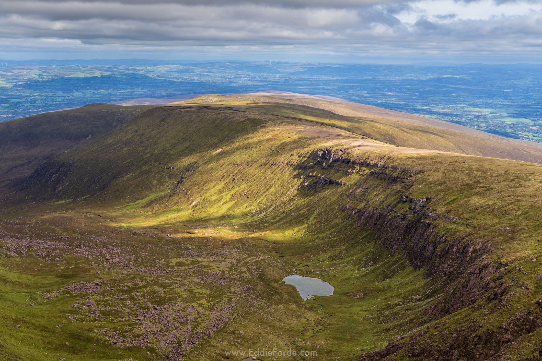
Once, you're up, take a break and take it all in for a while. To get to here is around is 4km. you could just spend you time here, relax and head back,, and it would of itself be a beautiful day out. But there’s no misery, this is reserved for the next section.


It’s fairly self explanatory where you are going next. Up! And it’s steep to go with it. It’s a good haul out the back of it. It is steep, did I say that already?
The ground is all grass and can be very wet in places. Once you get up to the ridge tho, just wow. Views the whole way back the Peninsula.
You could make a diversion here, go to the right and tick off Gearhane. There are really cool big conglomerate rocks there, with one in particular that looks. to me at least, like a small space ship. Again just imagining this walking around the place.


The video then covers the walk up to Baurtregaum. One thing to note is that the ridge just off Caherconree can be a bit narrow for some. I find it ok, just felt its worth mentioning just in case. The trek up to Baurtregaum is ok, It is a very rocky barren top though, as you can see in the video. Those enclosures are a welcome wind shelter. Looking down into Curraheen is stunning, absolutely stunning, To see it cut out of the ground, it’s really immense. While i’ve done a few times now, I don’t have a proper video on it,, and this will probably be the final big hike video for the Peninsula. I don’t know what im going to do after it,, but that’s a problem for another day.
I head back to the 723 spot height. Now, and what is not evident in the video at all, is the distance. It took about 30-40 mins to get to that spot height after leaving the view into Curraheen. It’s all absolutely fine, but the whole lot is on a slight incline which gets tiring on the legs
The chat at the spot height where I can see the face. I initially wasn’t going to put that in, but in the end decided to include it. I see that face every time I go up. I tried scribbling on it, but failed miserably, so just got something off photoshop new generative ai and used that for the face. While its not exactly what I see, it at least give and idea and you can make out the face yourself then once you know where to look. I enjoy it anyway, I hope you can see it too.
The chance going down worked out perfectly. While I did mention in the video I was using my maps for contours etc, when I was actually coming up the valley I was constantly looking at the hill and trying to judge where I could come down,,, in reality, that is what made me decide my route, the map was a backup. I just don’t want anyone to try do it based on what I do in the video, i’m, not an expert or anything.
And then we were down. It was a really enjoyable walk and now that i’ve found the new way down, it’s a one I will do a lot more in the future.
I have finally got around to updating this blog post. A few days late, I had even been thinking about not doing it, just posting the images, but it didn’t sit right after all the effort of the other blog posts.
I hope this added a bit more to it. If you’ve any questions, please leave them in the comments.
thanks again
Ed