Beenoskee
Watch the Video here on YouTube
A somewhat clear day on top of Beenoskee, Irelands 13th Highest Mountain situated in the Dingle Peninsula.
Delighted to get up here as the previous visit was a wash out.
Parked at BallyDuff Graveyard on the way from Stradbally to Conor pass, use after a bad bend. It’s necessary to walk back the road a few hundred meters until you get to a house with a lane up the side of it. Previous times when I passed I couldn’t see the lane as it was all over grown, however this time, the hedges had been cut and it was quite obvious. If you were to keep on walking you’ll come to another entrance with the actual Glennahoo Walk sign on the road, but its definitely better to get off the road sooner rather than later.
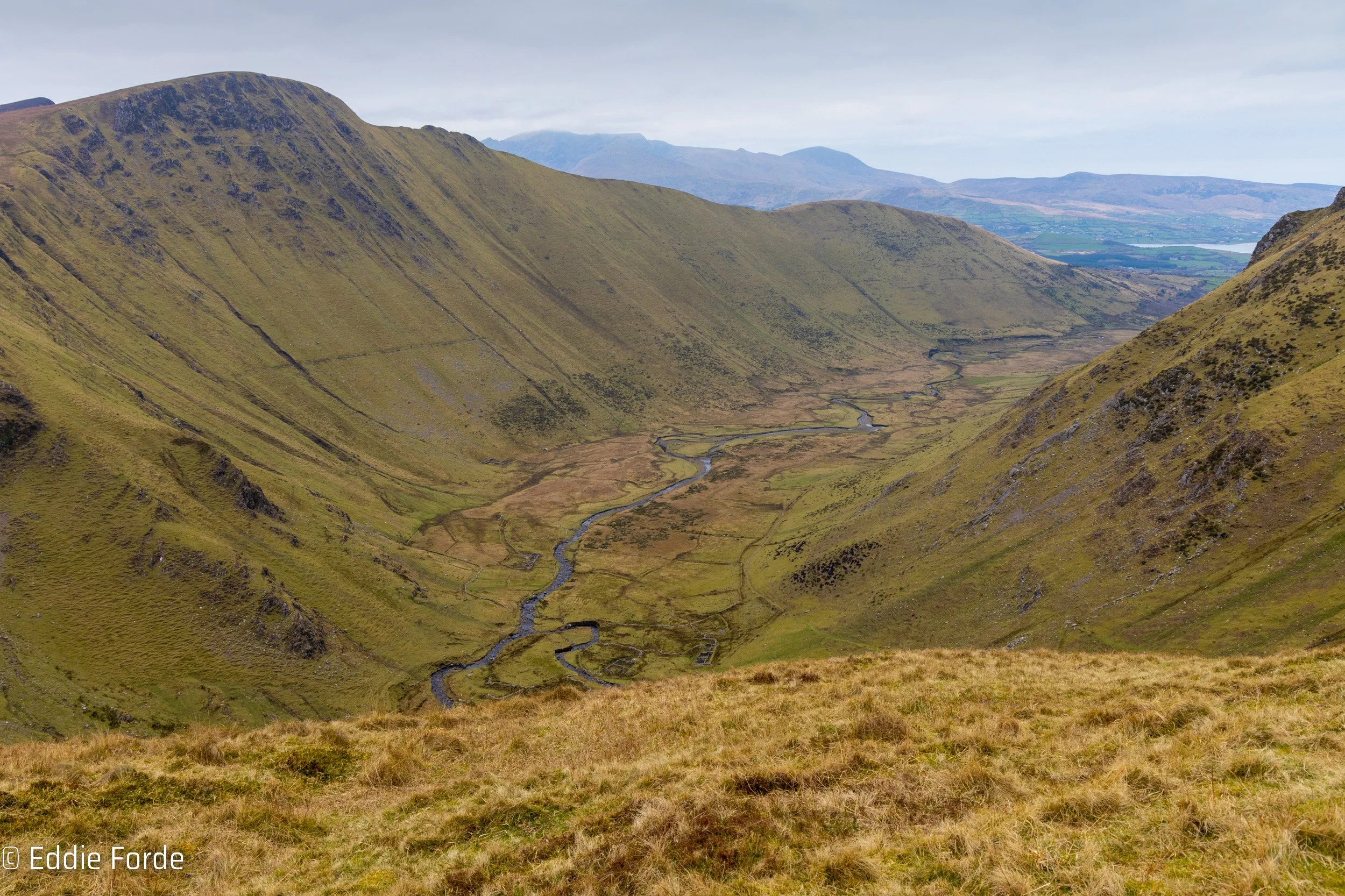
Within a few minutes we’re onto the road leading into the valley and once you pass the hedgerows the valley really begins to open up. Immediately you’re greeted by the beautiful Been overhanging the valley. That’s no for today and we’re going up left, up to Beenatoor. There’s nothing for it, just put the head down and make your way up.

Mountain Hare on Beenatoor
On the way up I saw what is a rare sight for me, a hare by the look of it. Once he saw me he was gone tho.
Getting to the top of Beenatoor you’re greeted with the most amazing views down into the valley. This is obviously completely unguarded mountain top so please be careful if going near the edge. While there was only a little breeze on this day, i’ve been up here when the wind was howling. Be safe.
As mentioned in the video it was Baltic up here, down the valley starting was nice, but up at higher elevations it was somewhat different. Messed around with the drone while up here, I think some of the shots came out ok and already I know what I should be looking out for the next time I get the opportunity. It’s not often I get to use a drone on the hills, as you can guess, its usually too windy…
Next it was a case of working along thru the bog, peat hags. The usual navigation and backtracking but overall it was ok. I decided against the short diversion up to Combane as I wanted to get to Beenoskee while it was still clear, you just can’t trust it.
The views from the top, even in the hazy weather are still something to behold. I was well happy to be up here and I think I must have said it 10 times if I said it once in the video. Loved it.
From a photography viewpoint, it was near impossible to get any decent images. The light was silver, pretty much no texture in the clouds and the haze totally washed out anything in the distance. You get days like these often in the mountains, I didn’t let it get me down. Anyway, on the way down I got some worth keeping.

Macha na Bó

Towards Knockmulanane and Annascaul Lake
Continuing on across the bog, which again had some peat hag hopping and backtracking we eventually come to the top of the back of the valley. It’s just something else altogether. Here is a collection of some of the best. No portfolio images but shots that give a good feel of the type of day it was.


Another fantastic day out. As I mentioned in the video the conditions were perfect for hiking, and only so so for photography, but it was still great to be out.
There are a few different ways up here, and I think the next time I will come from Annascaul Lake, just for something different.
EastWest Maps have an in interesting blog post on the name of this mountain read it here
Thanks for reading this, hope you enjoyed the images and the bit of extra detail.
Ed